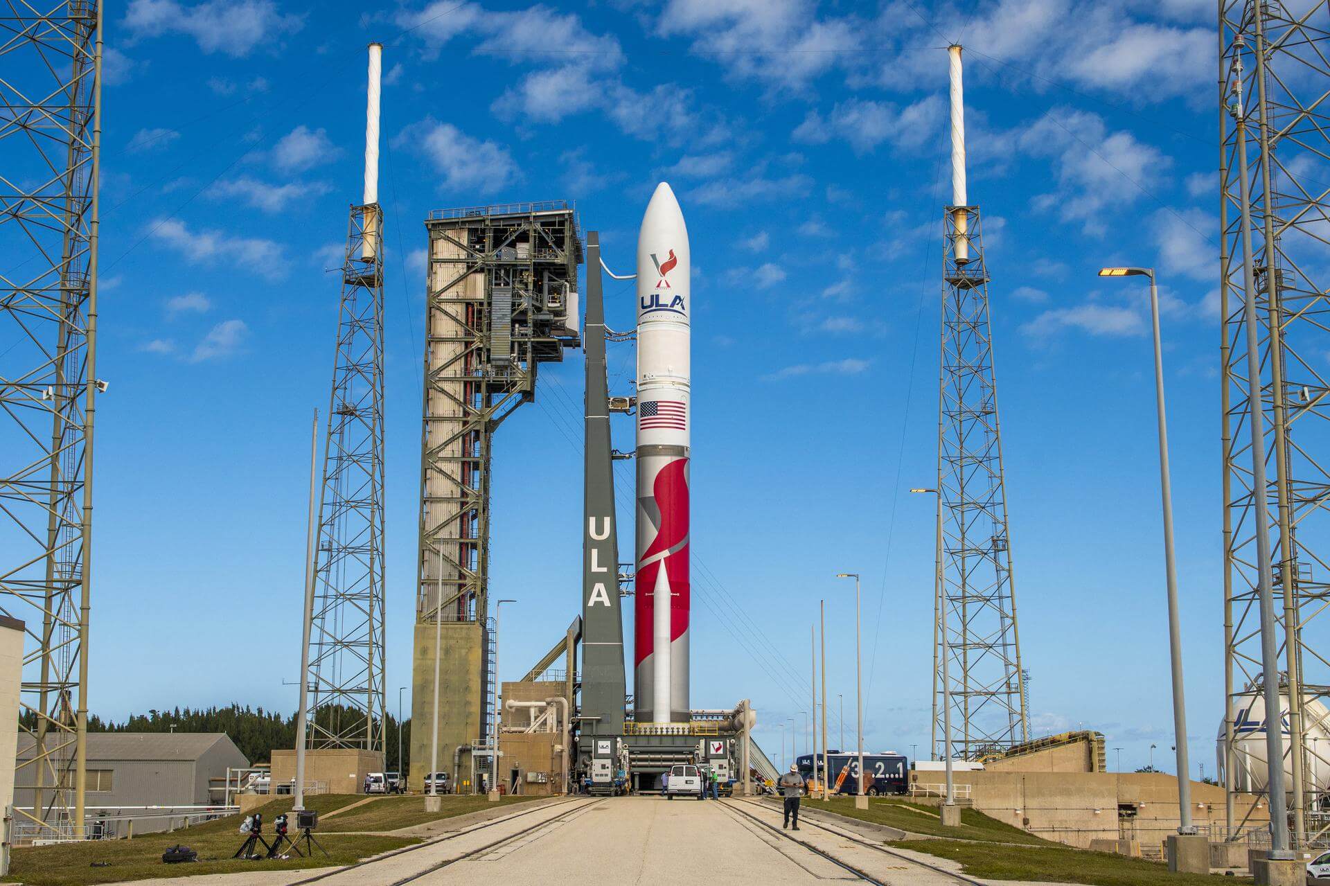
Vulcan
ActiveUnited Launch Alliance (ULA)
None
Description
Vulcan
Specifications
-
Stages
2 -
Length
― -
Diameter
5.4 m -
Fairing Diameter
5.4 m -
Launch Mass
― -
Thrust
―
Family
-
Name
Vulcan -
Family
― -
Variant
Vulcan -
Alias
― -
Full Name
Vulcan
Payload Capacity
-
Launch Cost
― -
Low Earth Orbit
― -
Geostationary Transfer
Orbit
― -
Direct Geostationary
― -
Sun-Synchronous Capacity
―
United Launch Alliance
Commercial
Interim CEO: John Elbon
ULA 2006United Launch Alliance (ULA) is a joint venture of Lockheed Martin Space Systems and Boeing Defense, Space & Security. ULA was formed in December 2006 by combining the teams at these companies which provide spacecraft launch services to the government of the United States. ULA launches from both coasts of the US. They launch their Atlas V vehicle from LC-41 in Cape Canaveral and LC-3E at Vandeberg. Their Delta IV launches from LC-37 at Cape Canaveral and LC-6 at Vandenberg.
Upcoming Spaceflights
Vulcan | USSF-23
United Launch Alliance | United States of AmericaCape Canaveral SFS, FL, USA
TBD December, 2026
Vulcan | NROL-64
United Launch Alliance | United States of AmericaCape Canaveral SFS, FL, USA
TBD December, 2026
Vulcan | USSF-112
United Launch Alliance | United States of AmericaCape Canaveral SFS, FL, USA
TBD December, 2026
Vulcan | USSF-16
United Launch Alliance | United States of AmericaCape Canaveral SFS, FL, USA
TBD December, 2026
Vulcan | WGS-11
United Launch Alliance | United States of AmericaCape Canaveral SFS, FL, USA
TBD December, 2026
Vulcan | USSF-43
United Launch Alliance | United States of AmericaCape Canaveral SFS, FL, USA
TBD December, 2026
Vulcan | GPS IIIF SV01
United Launch Alliance | United States of AmericaCape Canaveral SFS, FL, USA
TBD December, 2026
Vulcan | USSF-57
United Launch Alliance | United States of AmericaCape Canaveral SFS, FL, USA
TBD December, 2026
Vulcan | USSF-25
United Launch Alliance | United States of AmericaCape Canaveral SFS, FL, USA
TBD December, 2026
Vulcan | SDA Tranche 2 Transport Layer B
United Launch Alliance | United States of AmericaVandenberg SFB, CA, USA
TBD December, 2026
Vulcan | NROL-109
United Launch Alliance | United States of AmericaCape Canaveral SFS, FL, USA
TBD December, 2026
Vulcan | NROL-100
United Launch Alliance | United States of AmericaVandenberg SFB, CA, USA
TBD December, 2026
Vulcan | SILENTBARKER 2/NROL-118
United Launch Alliance | United States of AmericaCape Canaveral SFS, FL, USA
TBD December, 2026
Vulcan | STP-5
United Launch Alliance | United States of AmericaCape Canaveral SFS, FL, USA
TBD December, 2026
Vulcan | NROL-56
United Launch Alliance | United States of AmericaCape Canaveral SFS, FL, USA
TBD December, 2026
Vulcan | NROL-73
United Launch Alliance | United States of AmericaVandenberg SFB, CA, USA
TBD December, 2026
Vulcan | USSF-114
United Launch Alliance | United States of AmericaVandenberg SFB, CA, USA
TBD December, 2026
Vulcan | SDA Tranche 1 Tracking Layer D
United Launch Alliance | United States of AmericaVandenberg SFB, CA, USA
TBD December, 2026
Status: To Be Determined
Mission:
Tranche 1 Tracking Layer D is one of five missions by the United States Space Force Space Development Agency (SDA) for the Proliferated Warfighter Space Architecture (PWSA) Tranche 1 Tracking Layer constellation, which will provide global indications, warning, tracking, and targeting of advanced missile threats, including hypersonic missile systems.
Polar OrbitVulcan | SDA Tranche 1 Tracking Layer B
United Launch Alliance | United States of AmericaVandenberg SFB, CA, USA
TBD December, 2026
Status: To Be Determined
Mission:
Tranche 1 Tracking Layer B is one of five missions by the United States Space Force Space Development Agency (SDA) for the Proliferated Warfighter Space Architecture (PWSA) Tranche 1 Tracking Layer constellation, which will provide global indications, warning, tracking, and targeting of advanced missile threats, including hypersonic missile systems.
Polar OrbitVulcan | NROL-83
United Launch Alliance | United States of AmericaVandenberg SFB, CA, USA
TBD December, 2026
Vulcan | USSF-95
United Launch Alliance | United States of AmericaCape Canaveral SFS, FL, USA
TBD June, 2027
Vulcan | USSF-70
United Launch Alliance | United States of AmericaCape Canaveral SFS, FL, USA
TBD September, 2028
Vulcan | GPS IIIF SV03 (USSF-15)
United Launch Alliance | United States of AmericaCape Canaveral SFS, FL, USA
TBD December, 2029
Vulcan | GPS IIIF SV02 (USSF-49)
United Launch Alliance | United States of AmericaCape Canaveral SFS, FL, USA
TBD December, 2029
Vulcan | NGG-2 (USSF-50)
United Launch Alliance | United States of AmericaCape Canaveral SFS, FL, USA
TBD December, 2029
Flight Record
No spaceflights found for .
Falcon 9
Cygnus CRS-2 NG-24 (S.S. Steven R. Nagel)
Space Launch Complex 40 - Cape Canaveral SFS, FL, USAThis is the 24th flight of the Orbital ATK's uncrewed resupply spacecraft Cygnus and its 23rd flight to the International Space Station under the Com…
Smart Dragon 3
SatNet test satellite
South China Sea (launch location 3) - Haiyang Oriental SpaceportOfficially described as "Satellite-Internet Technology Demonstration Satellite". Probable 1 (?) test satellite for the Chinese state-owned LEO commun…
Falcon 9
Starlink Group 17-21
Space Launch Complex 4E - Vandenberg SFB, CA, USAA batch of 25 satellites for the Starlink mega-constellation - SpaceX's project for space-based Internet communication system.
Long March 6A
SatNet LEO Group 21
Launch Complex 9A - Taiyuan Satellite Launch Center, People's Republic of ChinaA batch of 5 Low Earth Orbit communication satellites for the Chinese state owned SatNet constellation operated by the China Satellite Network Group.…
Long March 8
SpaceSail Polar Group 07
Commercial LC-1 - Wenchang Space Launch Site, People's Republic of China18 Low Earth Orbit communication satellites with Ku, Q and V band payloads for the G60 constellation operated by Shanghai Spacesail Technologies with…

